
—
In case we forget: The Disastrous Flood at the Cameron Highlands November 2013…
Cameron Highlands Year End 2015: More landslides, floods…?
The Cameron Highlands: 10 years left before the Mother of all catastrophes?
—
REMEMBER THESE WORDS…
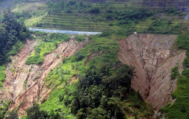
State Public Utilities, Infrastructure, Energy and Water Committee chairman Datuk Zainol Fadzi Paharudin said the condition of the road is not as critical as depicted in pictures.
“A RM10 million allocation has been utilised for remedial works and the 430m stretch is safe to use,” he told reporters when met at the site on Friday.
“The structure of the road has concrete beneath the surface, similar to that of a bridge,” he said.
The works, he added, were completed on December 24 last year.
—
The Perak PWD insists that the photo is old, that it was taken in late 2014, and that the road had been fixed.
What about these photos produced by Bernama? Are they recent or old?
Pandangan terkini cerun yang rebak di KM 44, Jalan Simpang Pulai-Cameron Highlands.


—
17 July 2016
…
Malay Mail Online @themmailonline
Erosion at slope gives motorists jitters
…
CAMERON HIGHLANDS, July 17 — Residents here still fear using the Simpang Pulai stretch despite being told the road was safe for use following inspections by soil experts and road engineers.
Cheong Yip Hing, 43, who uses the stretch twice daily, said he fears the road would give way each time he drives past.
“Whenever I use the road, I fear that something would happen, especially during the rainy season. The slope is steep and dangerous.
“Previously, landslides would only occur if the rain continues for more than a week, but now due to the downpour, landslides can happen any time.
“We know the government has done some maintenance in the area, but it wasn’t enough. The steep slope still can be seen. They should do something to cover it,” he added.
Resident Dilip Martin Anthony Rock, 29, said the Public Works Department (PWD) should take immediate action instead of releasing a statement saying that the road is safe to use.
“I think the road should be closed. The slope is getting nearer to the road.
“Road users do not feel safe using the road. The PWD should build an alternative road as there is a possibility of further erosion in the area,” he said.
Dilip, who is from Tanah Rata, added that precautions should be taken by the authorities instead of reacting after an incident.
#AWANInews Image on slope erosion at Jalan Simpang Pulai-Cameron Highlands is old pix – PWD http://english.astroawani.com/malaysia-news/image-slope-erosion-jalan-simpang-pulai-cameron-highlands-old-pix-pwd-111094 …

Bernama |  July 15, 2016 15:08 MYT
The Perak Public Works Department (PWD), in a statement which was posted on its Facebook account, said the picture was taken at FT185 Section 44 of the road in late 2014.
The department said installation of bored pile retaining structure had been carried out at the location under the supervision of the Kinta PWD and the work was completed early this year.
“The Kinta PWD will conduct an inspection at the location today,” it said.
Pandangan terkini cerun yang rebak di KM 44, Jalan Simpang Pulai-Cameron Highlands.
—
